Spectroradiomètres de terrain (LPG)
Présentation des ASD FieldSpec 3 du LPG
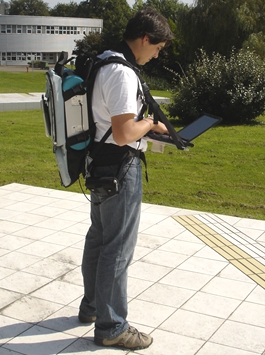

Le second ASD FieldSpec 3 du LPG a été financé en 2009 par le CPER 2007-2013.
CPER 2007-2013 GÉNIE CIVIL, ENVIRONNEMENT ET GESTION DURABLE DE LA VILLE R51_p6
Axe 3 : Application de la télédétection au génie civil environnemental et à la gestion durable de la ville (responsable P. Launeau)


SPECIFICATIONS TECHNIQUES :
Résolution spectrale : 3 nm @ 700 nm, 8,5 nm @ 1400 nm et 6,5 nm @ 2100 nm
Intervalle de mesure : 1.4 nm @ 350-1000 nm et 2 nm @ 1000-2500 nm
Vitesse de balayage : 0,1 sec./spectre
Détecteurs :
1 groupe de barrettes photodiodes (512 éléments Si) pour la gamme de 350 nm à 1000 nm
2 groupes de photodiodes InGaAs « TE cooled » pour les gammes 1000-1800nm et 1800-2500 nm
Contact
Applications
Launeau, P.; Méléder, V.; Verpoorter, C.; Barillé, L.; Kazemipour-Ricci, F.; Giraud, M.; Jesus, B.; Le Menn, E. Microphytobenthos Biomass and Diversity Mapping at Different Spatial Scales with a Hyperspectral Optical Model. Remote Sens. 2018, 10, 716. https://doi.org/10.3390/rs10050716P. Launeau, Kassouk, Z., Debaine, F., Roy, R., Mestayer, P. G., Boulet, C., Rouaud, J.-M., & Giraud, M (2017). “Airborne hyperspectral mapping of trees in an urban area”. International Journal of Remote Sensing, 38:5, 1277-1311
Cesbron, F., Metzger, E., Launeau, P., Deflandre, B., Delgard, M.L., Thibault de Chanvalon, A., Geslin, E., Anschutz, P., Jézéquel, D. (2014) “Simultaneous 2D imaging of dissolved iron and reactive phosphorus in sediment pore-waters by thin-film and hyperspectral methods”. Environmental. Science & Technology Environmental Science and Technology, 48, 2816-2826.
Kazemipour F., P. Launeau, V. Méléder (2012) “Microphytobenthos biomass mapping using the optical model of diatom biofilms: Application to hyperspectral images of Bourgneuf Bay”. Remote Sensing of Environment 127 (2012) 1–13
Kazemipour F., V. Méléder, P. Launeau (2011) “Optical properties of microphytobenthic biofilms (MPBOM): Biomass retrieval implication”. Journal of Quantitative Spectroscopy and Radiative Transfer, Volume 112, Issue 1, January 2011, Pages 131-142
Baissa R., K. Labbassi, P. Launeau, A. Gaudin, B. Ouajhain (2011) “Using HySpex SWIR-320m hyperspectral data for the identification and mapping of minerals in hand specimens of carbonate rocks from the Ankloute Formation (Agadir Basin, Western Morocco)”. Journal of African Earth Sciences, 61, Pages 1–9
Barillé, L., Robin M., Harin N., Bargain A., Launeau P. (2010) “Increase in seagrass distribution at Bourgneuf bay (France) detected by spatial remote sensing”. Aquatic Botany, Volume 92, Issue 3, Pages 185-194.
Roy, R., P. Launeau, V. Carrère, P. Pinet, G. Ceuleneer, H. Clénet, Y. Daydou, J. Girardeau, and I. Amri (2009) “Geological mapping strategy using visible near-infrared–shortwave infrared hyperspectral remote sensing: Application to the Oman ophiolite (Sumail Massif) ”. Geochem. Geophys. Geosyst., 10, Q02004, doi:10.1029/2008GC002154.
Combe, J. P.; Launeau, P.; Pinet, P.; Despan, D.; Harris, E.; Ceuleneer, G.; Sotin, C., (2006) Mapping of an ophiolite complex by high-resolution visible-infrared spectrometry, Geochem. Geophys. Geosyt., 7, Q08001 (doi:10.1029/2005GC001214).
Combe, J.; Launeau, P.; Carrere, V.; Despan, D.; Meleder, V.; Barille, L.; Sotin, C., (2005), Mapping microphytobenthos biomass by non-linear inversion of visible-infrared hyperspectral images, Remote Sensing of Environment, 98, (4), 371-387.
Conditions d'utilisation
Les acquisitions d'images en laboratoire sont soumises à une tarification du LPG et à la disponibilité des personnels du LPG.
< retour
Equipe